


 July 02,2023
July 02,2023
July 02,2023
Looking for the best biking trails in Union City? Whether you're getting ready to bike, hike, trail run, or explore other outdoor activities, to explore the following 6 scenic trails in the Union City area. You'll discover kid-friendly routes for your next family trip and that are perfect for riders of electric bikes and outdoor enthusiasts at any skill level.
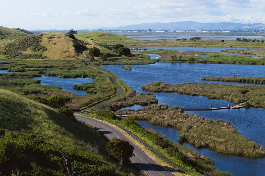
1.Bayview and Meadowlark Trail Loop
Gentle climbs, scenic bay views, and traces of American Indian heritage await at the west edge of Fremont, California. Coyote Hills Regional Park is a great place to introduce a friend to hiking.
If the modest hills overlooking San Francisco Bay force you to work up a sweat on the way up the Red Hill Trail, you can cool down by walking the wide gravel Bayview Trail along the water's edge.
An enlightening side trip is to the Tuibun Village site east of the marshes near the Visitors Center. The Tuibun Ohlone Indians built a shell mound there 2,000 years ago.
If you're feeling really ambitious, take the trail over Highway 84 and check out the birds and other animals at the Don Edwards San Francisco Bay National Wildlife Refuge (note dogs aren't allowed there).
Accessibility: There are 2 designated accessible spaces in the paved parking lot off of Patterson Ranch Road at the east end of the trail. Both of them are van-accessible with striped access aisles. The trail surface is paved asphalt with some bumps and cracks. It is typically at least 6 feet wide.
The most accessible portion of the trail is the northern loop in the first 2.5 miles. The majority of the trail is estimated to be in the mostly gentle (5% or less) grade category but there are steeper sections at about 2.5-2.9 and 3.1-3.2 miles when going counterclockwise.
2.High Ridge Loop Trail
The route also provides impressive views of the San Francisco Bay and the nearby East Bay Hills; expect to see raptors, deer and the occasional coyote. Trails on this route: High Ridge Loop Trail, Spur to Gossip Rock loop, Tolman Peak Trail, South Fork Trail, High Ridge Loop Trail. Skip the Tolman Peak section to slice three miles from the hike. Best times to go: Early to late spring, when the hills green up and the wildflowers put on their annual show. Winter is fine, too, though bear in mind the trails get very muddy. Give them a few days to dry out after a passing storm system blows through. Summer's too hot, but cooler weather in the autumn make the hiking pleasant.
3. Pioneer Trail
Find a break from the sun in Dry Creek Pioneer Regional Park with this short jaunt through the wooded ravines. Starting from the junction with the Meyers Ranch Trail, follow the trail through a wooded ravine to climb the hillside. Eventually, the trail trades one ravine for the other, and a climb for a descent, as it makes its way through another scenic ravine to reach its end on the High Ridge Loop.
4. Coyote Hills Half Marathon Loop
This is a great way to experience to experience the San Francisco bay. From the strong smell of salt, to the spectacular views, this trail will put you in the center the bay like nothing else.
There is no water along the trail. I recommend to bring plenty of water with you. Despite being so spectacular, the Shoreline Trail is not very popular among hikers. So be prepared, you'll be alone most of the time.
Coyote Hills was the location of a Native American village of the Ohlone tribe. We still have the opportunity to enjoy what is left of an ancient ecosystem where humans were sharing this area with sea otters, tule elks, and condors.
The trail starts at the Visitor Center on Marshlands Road. You can easily find parking here and it's free. From the road, take the Apay Way on the right after going over the freeway. The trail passes the Dumbarton Quarry on your right and starts running along the coast.
Stay on the coast for 3.5 miles. Halfway down, the Apay Way Trail becomes the Bayview Trail. When you reach the Alameda Creek, turn left on the Alameda Creek Trail (paved trail) pointing to the bay. At the end of the creek, the trail turns left pointing to the Dumbarton Bridge.
You are now on the Shoreline Trail. The trail is almost magic: the bay is on your right and the salt flats on your left. Once you finally reach the bridge, turn left and you're back on Marshlands Road. A few miles and you're back at the Visitor Center where you started.
5.Seasonal Loop Trail
An offshoot of the main Eden Landing Trail which can be combined to create a large loop. The first part of the spur can be accessed year-round; seasonal access beyond this point.
6.Hayward Shoreline to Eden Landing Ecological Reserve
This section of the San Francisco Bay Trail travels east from the Hayward Shoreline Interpretive Center and continues through the top of the Eden Landing Ecological Reserve. The first section follows Breakwater Avenue, and while there is no sidewalk here, there's enough of a parking lane for hiking to feel comfortable on this dead end road. Look for the entrance to the pedestrian bridge on the left that will lead over Highway 92.
Magicycle 52V Most Powerful Fat Tire Electric Bikes Only $1589!10% OFF for All Accessories. Limited Offer. Don't miss it! Free Shipping for Order over $50.


